 |
Our cottage at Sweet Valley, #4
|
The second week of September brought wonderful Fall weather with it, and the chance for a last minute camping trip to explore some more state parks. September has always been a favorite month of mine for hiking, and we have had a very prosperous month so far of trail exploration. Since we both had several days off, we decided to head a little farther away from home. We thought we would head towards the Delaware gap area, but our plans led us instead to very pleasant Sweet Valley Cottages, which was conveniently located near Ricketts Glen State Park. Some things are just meant to be, and this reservation provided us with a relaxing little cottage next to a pond. Upon arriving at the cottage we were greeted by a pair of swans and two ducks that we later nick-named Fred and Ethel. Fred and Ethel greeted us every night and every morning at our door. They followed us faithfully thinking we would provide them with food. We were one of only two couples camping that week, so it was extremely quiet outside of the antics of the ducks and swans. I don't think the male swan liked me very much, and admittedly I was a little afraid of him strutting around me since he was almost as tall as me with his neck stretched out.
 |
| Big Daddy Swan |
 |
| Dave by the pond with Fred and Ethel in the back. |
 |
| Adams Falls on the Evergreen Trail |
We arrived at the cottage around 10 am, and by noon we were out on a trail at Ricketts Glen State Park. This was actually our second visit. During the first trip about 10 years ago, we took the Falls Trail, a very challenging hike. This time we started at the south end of the park and took the Evergreen trail where we saw Adams Falls, this was an easy mile long trail.

This was a nice trail to start, and it boosted our confidence to continue on to the next. Traveling up to the visitor center at the north end, we got our sixth stamp in the passport book. We crossed the Lake Jean bridge, also part of the dam; and parked at the Lake Rose parking lot. We started at the Bear Walk Trail, 1 mile of easy walking; hooking onto a portion of Glen Leigh and then headed towards the Highland Trail.
The Onondaga Falls is situated on the Glen Leigh, this was the farthest point south that we hiked, from here we turned to the Highland Trail.
  |
| Onondaga Falls just before heading onto the Highland Falls |

These trails weaved through thick woods and outcrops of boulders. The midway crevasse was an interesting formation; some of the boulders seemed to be a fragile teetering puzzle waiting for a little movement to shift them into a different formation.


**************************************************************************************
September 13th was spend exploring the beautiful Endless Mountains in Sullivan County's World's End State Park. Here is some trivia about this park name. Early in its history it was known by some as Whirl's End because of the whirl pool that used to exist in the Loyalsock Creek. Some referred to it as Whirl's Glen, but today it is know as World's End. Amazing views of the convergence of these 5 mountains really does make you feel like you are at the end of the world. There were so many trails to decide on. After checking in at the visitors center for a map and stamp #7 we decided on starting at the World's End Trail. The visitors center is really nice; the ranger said the building was 10 years old, but it looks brand new and has some really interesting information about the wild life. Its the first time I've seen a cinammon colored Black Bear, which I didn't know existed, but apparently 2% of Black Bears have the cinammon shade.
 The World's End trail was very challenging and we really needed our walking stick to help us manage the steep inclines. I have to tell you I have a "High Anxiety" and it took a lot for me to treck on the edge of these straight up trails that didn't give any protection from the feeling that you were going to drop off the edge into the thick timbers below; but I still loved the challenge and really felt like I accomplished something when we finally reached the the cross roads at 1600 ft where we turned onto the Loyalsock Trail aka Pioneer Road. Loyalsock is the longest of the World's End trails, running 59.21 miles, but we were on this trail for less than 3 miles when we connected to the Double Run Nature Trail. The point before we got on Double Run led us to the cool valley of the west bank of the Double Run creek. We actually had a pair of rugged stairways to help us traverse the steep slope at the start of Double Run. We were on Double Run for a while, descending finally to foot bridges that took us closer to the Loyalsock Creek.

These trails were well worth taking, and gave us a little different view of Ricketts Glen. We only passed two other couples on the trail- both were walking without water, a big mistake for the many miles of trails located at this park. We strongly suggest that you carry water and a first-aid kit minimally. We also use a walking stick, especially if the trails are classified as difficult. I would also suggest that before staring any trail, you take the time to pick up a trail map. On this particular hike, the couples we met were without a map and had lost track of where they were on the trail- not a good thing when walking many miles, especially with the daylight getting shorter this time of year and when walking during the week when there are not as many people on the trail. We always carry a backpack water bladder, mosquito repellent, and a snake bite kit when doing shorter hikes. We prepare more for days when the hikes are longer or more difficult and hubby also carries our large backpack.
**************************************************************************************
 |
| Are we Yankees fans??? You bet! |
 The World's End trail was very challenging and we really needed our walking stick to help us manage the steep inclines. I have to tell you I have a "High Anxiety" and it took a lot for me to treck on the edge of these straight up trails that didn't give any protection from the feeling that you were going to drop off the edge into the thick timbers below; but I still loved the challenge and really felt like I accomplished something when we finally reached the the cross roads at 1600 ft where we turned onto the Loyalsock Trail aka Pioneer Road. Loyalsock is the longest of the World's End trails, running 59.21 miles, but we were on this trail for less than 3 miles when we connected to the Double Run Nature Trail. The point before we got on Double Run led us to the cool valley of the west bank of the Double Run creek. We actually had a pair of rugged stairways to help us traverse the steep slope at the start of Double Run. We were on Double Run for a while, descending finally to foot bridges that took us closer to the Loyalsock Creek.
 |
| This was a very relaxing part of the hike and allowed us to catch our breath |
The last leg of the trail was longer than we expected and we found ourselves weaving in and out of huge piles of debris which we found out was created by the tropical storm that blew through the area in Sept. of 2011 when the area flooded causing roads to collapse and the creek trail path to be diverted.


The warm sun was soothing, and the edge of the creek beckoned us to spend some time on the rocks.. I even soaked my feet in the cool water.
 Mid-week off-season is a great time to hike, but some of the drawbacks are the typical summer businesses (like ice cream shops, etc.) are closed. No matter- we treated ourselves to an awesome pizza dinner at a local joint on the intersection of Rts 118 and Sweet Valley- yum, just what the doc ordered to energize us and get us ready to start a camp fire and toast marshmellows. You are never too old for the traditions, and we enjoyed the cool night air as we rested by the fire. We felt pretty good about ourselves for the amont of hiking we accomplished today- we hope you have a chance to visit this park and take in some of the vistas.
 Mid-week off-season is a great time to hike, but some of the drawbacks are the typical summer businesses (like ice cream shops, etc.) are closed. No matter- we treated ourselves to an awesome pizza dinner at a local joint on the intersection of Rts 118 and Sweet Valley- yum, just what the doc ordered to energize us and get us ready to start a camp fire and toast marshmellows. You are never too old for the traditions, and we enjoyed the cool night air as we rested by the fire. We felt pretty good about ourselves for the amont of hiking we accomplished today- we hope you have a chance to visit this park and take in some of the vistas.
***************************************************************************************
We packed up on Friday morning from our cottage and headed to our final state park of the week at Tuscarora State Park in Schuylkill County. Deciduous forest and meadows by Locust Mountain provided a very relaxing environment. Our hike took in a 1.2 mile on the Laurel, Edge and Log trails ( easy), 4.5 miles on the more difficult Spirit Trail. Spirit Trail was not near as difficult as our the World's End Trail.

We saw lots of tiny little toads, but thankfully no snakes.
The Locust Creek meanders along a portion of this trail and offers a freshing coolness to the hike
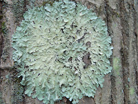
We saw some interesting fungus and lichen. Hope you are enjoying the pics...


 Beautiful meadows full of wild flowers and butterflies filled our view from easy walking mowed paths that came at the end of our walk. The day was very sunny and the high 70s temp made for a perfect ending to our hikes this week. Each of the state parks has its own personality. Tuscarora is laid back and easy feeling, so if that is what you are looking for you should try this park. It became our 8th park to check-off in our passport book.


 |
| Tuscarora State Park |

After Thursday's more strenuous trails, this park felt a little simpler which I appreciated. The park is said to be popular for fishing, and there were a couple people fishing on this day.
 |
| Locust Creek was a very pleasant babbling brook |
We saw some interesting fungus and lichen. Hope you are enjoying the pics...


To finish up this blog, I have to admit that we got Locust Lake State Park stamped in our book, but missed finding the park (signage didn't seem to be to good, and the roads were very windy making it difficult to pay attention to signs). Too tired to back-track and search again we headed home. It is fairly close by, so we will pick it up later when when we only have a few hours to kill for traveling/hiking. The Tuscarora office just got their stamps in, so we were the first to get 'stamped'. Note that Tuscarora and Locust are in fairly close proximity and I think coordinate with one another; Locust Lake has only a small satelite office. So we headed back to Rts. 54 and 61 taking us into Frackville and back into our neck-of-the-woods.
No comments:
Post a Comment